Várak és erődített helyek a Kárpát-medencében
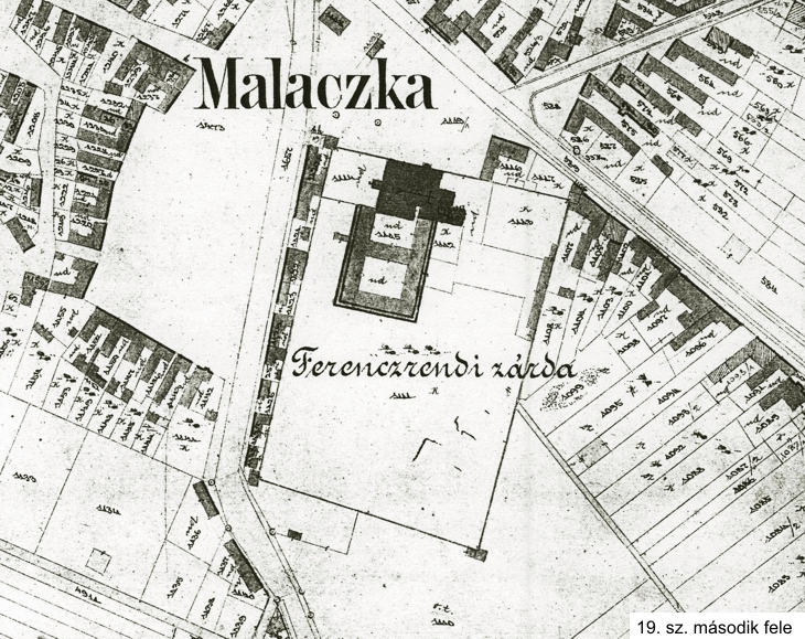
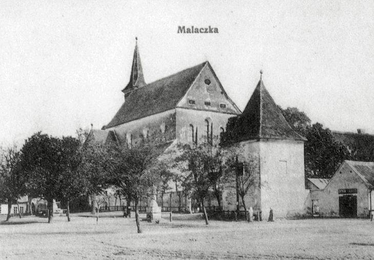
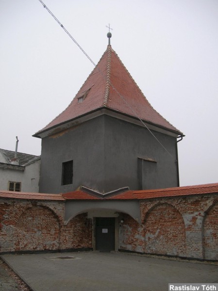
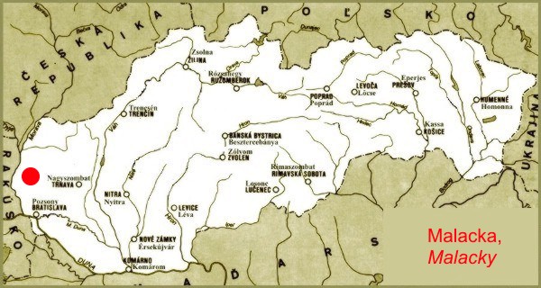
Malacka - Malacky, Szlovákia, Felvidék, Pozsony vármegye - Templom ()
- Áttekintés
- Történelem
- Fotók
- Alaprajzok
- Ábrázolások
- Térkép
- Szállás
Malacka – kolostorerőd -- Malacky
Vármegye: Pozsony
Ország: Szlovákia
Régió: Felvidék
Helységnév 1: Malacka – kolostorerőd
Helységnév 2: Malacky
Leírása:
Csak egy helyszíni terepbejárás után lehetne a részletekig pontosítani, hogy a XVII. században emelt főúri várkastélyból kialakított ferences rendi kolostor épülete {„Fekete kolostor”} hogyan nézhet ki napjainkban. Leírások szerint tornyai és védőfalai jelenleg {2005} is részben fennmaradtak.
Megközelítése:
Szlovákia Ny-i részén, Pozsony {Bratislava} városától É-i irányban kell elindulni a gépkocsival utazóknak a D 2-es autópályán vagy a vele párhuzamosan futó 2-es főúton, hogy elérhessék Malacka {Malacky} városát. A történelmi levegőjű település főterétől D-i irányban emelkednek a főnemesi várkastélyból átalakított egyházi épülettömb falai.
Története:
1641 előtt – Amikor a Balassa főnemesi család birtokolta ezt a vidéket, akkoriban épülhetett fel nemesi szállásukként egy reneszánsz stílusú várkastély a mezőváros területén.
1641 után – A feltétlen Habsburg-hű Pálffy família földesúri fennhatósága idején letelepített ferences szerzetesrend az egykori Balassa várkastély épületét is felhasználta az új kolostor épület kialakításához.
-- Vele kapcsolatos katonai eseményről {ostrom} nem maradt fenn adat.
2005 – Napjainkban is megtekinthető a kolostorerőd.
Irodalom:
Csorba - Marosi - Firon: Vártúrák kalauza III. {1983} 139. old.
Szombathy Viktor: Szlovákiai utazások {1980}62. old.
{Szatmári Tamás}
Malacky Fortified Monastery
The monastery is situated in the position Čierny les within the focal intravillan of Malacky (district Malacky, altitude 158 m), a town generally considered cultural, administrative and
trade centre of the southern part of Záhorie region, the Slovak Republic. From the point of view of geomorphological unit it belongs to Bor Lowland (Borská nížina), subunit Záhorie Plains (Záhorské pláňavy), from the point of view of historical administrative division it belongs to
the former Bratislava Stolitz.
After the fall of the Great Moravian Empire both Bohemian and Ugrian sovereigns made efforts to acquire strategically important territory of Záhorie region, spreading between the Morava River and the Small Carpathians (Malé Karpaty). In the course of the eleventh and twelfth centuries this region used to be part of a deliberately uninhabited frontier defensive zone known as the Confinium. The forthcoming century, however, was about to set up new social structure, residential basis and state management in Ugria. At that time, King Andrew II (1205 – 1235) of the Árpád dynasty began distributing the royal lands among his vassals in return for military duty or political support. On account of making no real benefit, inasmuch as the southwestern borders had been already sufficiently petrified, the Confinium lost its importance and thus became subject to the division process too.
The first written reference about Malacky goes back to 1206 and can be found in the regal deed of donation according to which Count Alexander descended from the Hunt-Poznans, a noble lineage of Slavonic (Slovak) origin, should obtain feudal estate comprising Plavecký Štvrtok (“prædium Cheturtuchyel”) and several other guardian hamlets in Záhorie region. One of them was Maliscapotoca (“hamlet by the Malina Stream”), a protonymic present-day Malacky. Those Hunt-Poznans who owned Malacky would later gain other areas all over the region, establish an autonomous Plavec Castle estate, and become a specific branch of the lineage. Historiography often calls them “counts of Svätý Jur and Pezinok” after the towns they chose as their principal seats. Malacky gradually belonged to further noble lineages including the Szerédys, the Salms, the Fuggers and the Balassas. The last mentioned paid huge attention to Malacky with the purpose of installing it their family residence. They built here, amids marshes within an opulent hunting grounds, a lesser fortified manor house right in the place of an older water castle.
After the local Balassas had died off in the first half of the seventeenth century, Malacky went under ownership of its ultimate landholders, the Pálffys, in 1634. On decision made by Viceroy and Palatine Paul IV Pálffy of Ardud the earlier Balassan sixteenth century fortified manor
house, being devastated those times, got converted into a fortified monastery. When he signed the monastery´s foundation charter on 11 October, 1653, the adaptation works had been already effecting for several years. The interior of the Roman Catholic church of the Immaculate Conception of the Blessed Virgin Mary, added to the monastery itself, was finished in 1660. Nevertheless, the first Franciscans arrived here in 1652 at the latest, being invited to proceed
with the re-Catholicism which had been previously started by the last Balassas.
The whole complex was built in the Renaissance-Baroque style and much of it has been preserved until nowadays. The U-shaped three-storeyed rectangular monastic building approximately follows the ground plan of the former manor house, and its longer parallel wings
directly adjoin the church´s single-naved architectural structure on the northern side. There is also a connecting wing laid between the longer parallel wings at their midpoint. Such configuration used to create two enclosed rectangular inner courts called “Edenic garden”. In the twentieth century´s interwar period the original southern wing was pulled down to be replaced by modern body of the newly established public Gymnasium of the Order of St Francis of Assisi. Besides this, several further buildings of various function later appeared inside the area as well.
The fortification surrounding the premises of the monastery comprises brick wall and four quoin towers. All the monastic buildings are situated in the upper part of the fortified area, and the church´s northern side forms an integral part of the fortification wall. Judging from the vast dimensions of the lower empty part of the area, this must have served as a refuge for the citizens. The quoin towers are represented by polyhedra with square ground plans (6 × 6 m, except the northwest one: 7 × 7 m) and pyramidal tiled roofs. Each of them still carries subtle relics of embrasures and has been more or less inappropriately treated a long time – the northwest one adjacent to the church´s courtyard was rebuilt into Chapel of God´s Mercy (originally known as Chapel of St Rochus), the northeast one is currently being utilised for commercial purposes, the southwest one is a private property, and the southeast one just goes to waste.
The fortification wall has an irregular rectangular ground plan with measurements of 138 m (northern side), 131 m (southern side), 199 m (eastern side) and 184 m (western side). Its height is up to 2.5 m. It possesses neither loopholes nor battlements and is thus supposed to have provided only a passive defence. There is an ornamental arcuate pattern repeating throughout the wall´s inner side. The wall used to have three entrance gates – two on the northern side (both still existing) and one on the western side (terminated now). Partial preservation of the wall is mainly given by its considerable size and close urban environment – the northern frontal branch was impaired by widening the newest gate (present-day official triple entrance), the eastern one suffers damage due to an artificial access way, the southern one has remained intact, and the western one has been continuously demolished by building up the houses along it. The fortification wall is thought to have been fractionally following the authentic bulwark of the Balassan unit. The monastery was fortified in consequence of the anti-Habsburg rebellions as well as the simultaneous Ottoman threat.
From among the interior artefacts of the monastic church undoubtedly deserves attention an
exact copy of the Holy stairs (the original of which was transferred from Jerusalem to Rome in the fourth century AD), sculptural epitaph of Palatine Nicholas V Pálffy of Ardud by John Moll and Anthony Coradini from 1741, the chief Baroque-Classical altar by an unknown author from 1720, Baroque organ by friar Quido Dietrich from 1729, or the Pálffian underground burial crypts.
Malacky Fortified Monastery or the so-called Black Monastery also appears on a few historical iconographic records, tangibly on a tailor´s guild certificate by an unknown author from 1833,
a drawing by an unknown author from 1866 (there can be seen the Prussian Army encampment
in front of the monastery), a drawing by an unknown author from 1868, and an altar painting by Anthony Veselý from 1848 placed in the Holy Trinity church, the town´s other sacral edifice.
Literature
BALÁŽIKOVÁ, Jana – HAVLÍK, Marián: Ukrižovaný Kristus – drevená polychrómovaná socha z Malaciek. In: Pamiatky & múzeá, 2005, no. 2, pp 58 – 60 (re: 58).
BELLAN, Stanislav – ŠÍP, Vladimír – YURKOVIC, Vladimir: Malacky 1206 – 2006. First edition. Malacky: town of Malacky 2006. 144 pp (passim).
Encyklopédia miest a obcí Slovenska. First edition. Lučenec: Ps-Line 2005. 960 pp (re: 44 – 46).
Encyklopédia Slovenska IV. First edition. Bratislava: Veda 1980. 696 pp (re: 249 – 250).
GERGELYI, Otmar – WURM, Karol: Historické organy na Slovensku. Historische Orgeln in der Slowakei. First edition. Bratislava: Opus 1982. 368 pp (re: 106).
HALLON, Pavol: Dejiny františkánskeho chrámu Nepoškvrneného Počatia Panny Márie v Malackách. First edition. Skalica: Záhorie Museum 2001. 48 pp (passim).
HORVÁTH, Pavol: Obrazy slovenských miest na výučných listoch cechových remeselníkov. In: Vlastivedný časopis, 1964, no. 1, pp 42 – 43 (passim).
KOLLÁR, Daniel – OVEČKOVÁ, Jana – OVEČKOVÁ, Mária: Slovensko-rakúske Pomoravie. First edition. Bratislava: Dajama 1996. 213 pp (re: 42 – 44).
KRIŽANOVÁ, Eva – PUŠKÁROVÁ, Blanka: Hrady, zámky a kaštiele na Slovensku. First edition. Bratislava: Šport 1990. 258 pp (re: 135 – 136).
Kronika Slovenska 1. Od najstarších čias do konca 19. stor. First edition. Bratislava: Fortuna Print 1998. 616 pp (re: 246).
LUKAČKA, Ján: Formovanie vyššej šľachty na Slovensku. In: Pamiatky & múzeá, 1999, no. 2, pp 14 – 18 (passim).
Mestá a obce Slovenska. First edition. Košice: Donatus 1999. 284 pp (re: 68 – 69).
Osemstoročné Malacky. Zborník príspevkov zo seminára. First edition. Malacky: town of Malacky, and Malacky: Municipal Centre of Culture – Michal Tillner Museum 2006. 60 pp (passim).
Slovenský biografický slovník IV. First edition. Martin: The League for the Advancement of the Slovak Nation 1990. 608 pp (re: 380).
Súpis pamiatok na Slovensku II. First edition. Bratislava: Obzor 1968. 588 pp (re: 273 – 274).
ŠÍP, Vladimír – TREBIŠOVSKÝ, Július: Malacky. Kapitoly z dejín mesta II. First edition. Malacky: ZCK 1996. 244 pp (passim).
ŠTIBRANÁ, Ingrid: Pálffyovci ako mecenáši umenia. In: Pamiatky & múzeá, 2004, no. 2, pp 24 – 29 (passim).
Vlastivedný slovník obcí na Slovensku 2. First edition. Bratislava: Veda 1977. 528 pp (re: 215 – 217).
/Rastislav Tóth/
Új feltöltések, frissítések
Támogatás
Fotóink elérhetőek vászonképen!